Disclaimer: Any views expressed by individuals and organisations are their own and do not in any way represent the views of The Heritage Portal. If you find any mistakes or historical inaccuracies, please contact the editor.
Over the last few weeks there has been considerable discussion about the shocking state of George Harrison Park in Langlaagte (the site commemorating the discovery of the largest goldfield on earth). In the following thought-provoking piece Gavin Whitfield, geological consultant and author, argues that we should 'not waste further effort on maintaining this important heritage site as it is...'
History
According to the memorial stones at the still-imposing stonework gateway (see main pic), the park was officially opened to the public on 4th October 1947, on the 61st anniversary of the proclamation of the farm Langlaagte as a public digging. The park was created and named to commemorate the official discovery of the gold-rich Main Reef pebble conglomerate by itinerant Australian prospector George Harrison in early 1886. According to the records the park forms part of two claims* (No. 19 and 21) which were granted to George Harrison and his prospecting partner George Walker respectively by G. C. Oosthuizen, owner of Portion A of Langlaagte farm, in terms of mining law at the time. The site became a National Monument in 1944 and in terms of current heritage legislation is now considered a Provincial Heritage Site. (As an aside Harrison soon sold his claim for £10 and disappeared).
(* a gold claim was a 150 x 400 Cape feet; 1 Cape foot = 1. 033 English foot)
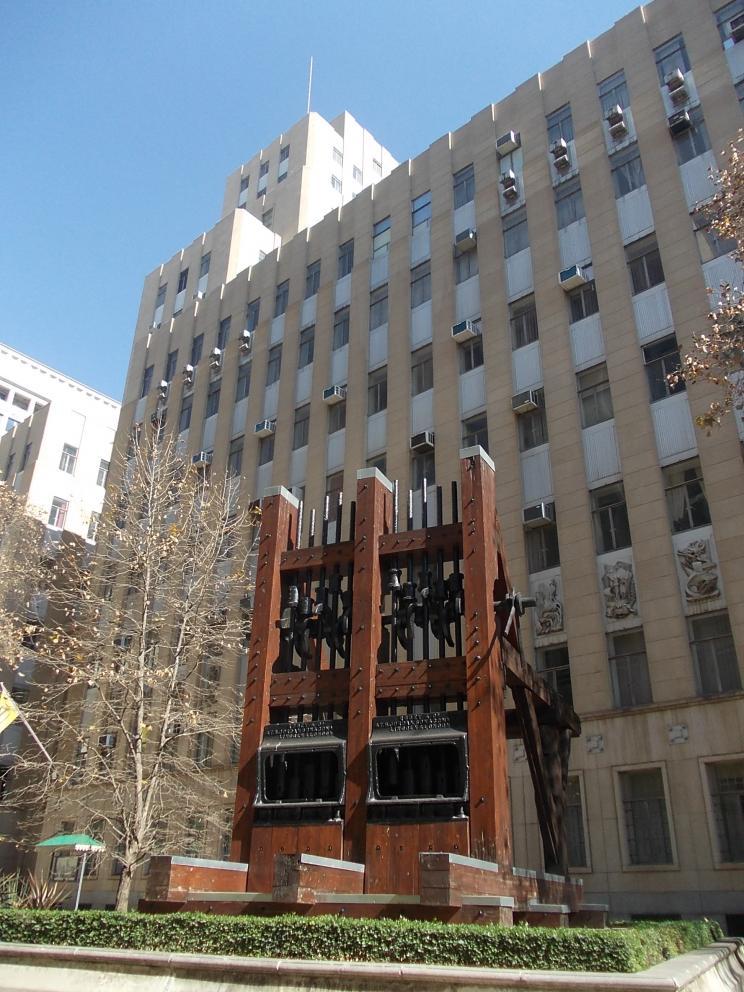
The gateway was erected by the City Council of Johannesburg “in honour of the pioneers of the Witwatersrand goldfields”. Also on site there was a 10-stamp mill (under a slate roof) that came from the Robinson Deep Mine. The woodwork to this was partly destroyed by vandals (for firewood) more than 10 years ago, but the machinery was renovated and re-erected in Hollard Street (now a pedestrian way) outside of the Chamber of Mines building. There was also other mining gear on site but this is long gone. Soon after the first Main Reef discovery the area became the site of one of the several Langlaagte gold mining syndicates that operated to the south of the line of the Main Reef.
Langlaagte Stamp Battery relocated to the Main Street Mining Mall
Ownership and development
Mining magnate J. B. Robinson was at the forefront, taking-up nearby claims (as mynpachts) and another group was the Paarl Syndicate which held the above claims area. In November 1886 the small township of Paarlshoop was laid out to the north of what is now Main Reef Road (at the same time as Johannesburg was being laid out). A variety of Langlaagte mining companies appear to have held the ground, and this in part became consolidated into the much larger Crown Mines area in 1909, ultimately part of the Rand Mines group. Surface rights were apparently donated by Langlaagte Estate G. M. and Crown Mines to the Historical Monuments Commission, later the now-defunct National Monuments Commission, before becoming the South African Heritage Resource Agency (SAHRA). The donated ground was later transferred to the City of Johannesburg and control now falls under management of Johannesburg City Parks. This iconic geosite was proclaimed a National Monument in 1944, as a memorial to the founding of Johannesburg and South Africa’s phenomenal gold mining industry.
BUT TAKING THE EMOTION AND SENSE OF OUTRAGE OUT OF IT, LET US LOOK AT GEORGE HARRISON PARK’S GEOLOGICAL, HISTORICAL AND SOCIAL CREDENTIALS.
The Main Reef Group and the “reef remnant”
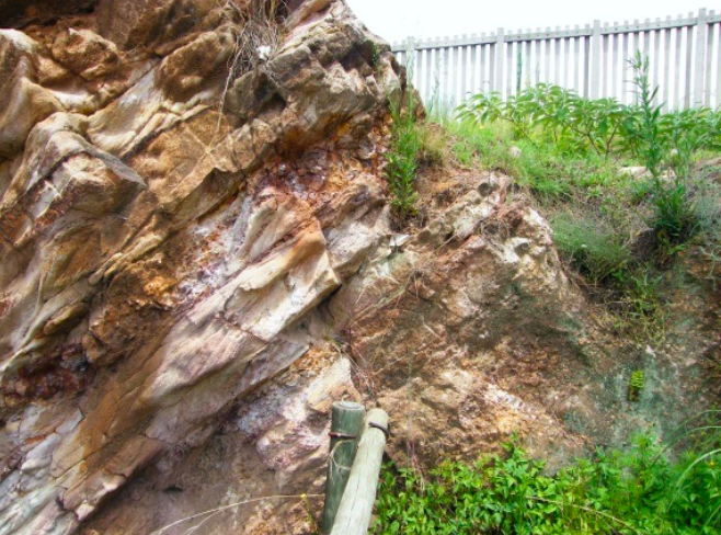
Here there existed a number of south-dipping, disconformity-bound, pyritic quartz pebble conglomerate “reefs”, including the Main Reef (MR), the Main Reef Leader (MRL), the South Reef, and stratigraphically below the MR, the North Reef. They are laterally persistent and the MR and MRL were the main gold-producing reefs of the Central Witwatersrand Goldfield. As such they were the founding formation of the gold industry. These reefs, within beds of weathered quartzite, are very well exposed in the sidewalls of the old working, dipping south at about 35°. These exposures are now restricted to this immediate site, having been almost mined away on both sides and down dip. Records show that the MRL was the most prolific, assaying at ounces per ton. It is an enigma why the George Harrison Park exposure was not mined, possibly remaining as a structural pillar next to the old incline shaft, or due to lower than normal gold content. As far as is known this is the only accessible, well-exposed example of in situ Main Reef that exists.
Portion of the ML and MRL in the Langlaagte working. The writer suggests that this geological section is expertly removed and conserved elsewhere
Wrong “address” and lack of local interest
George Harrison Park (GHP) has an important-sounding address along Main Reef Road, and must have been the creation of an enthusiastic group of people in the 1940s when there was little development in this area – although by then the main road was in existence. It lies between an unstable mined-out area to the south, exacerbated by an eyesore of more recent open-cast mining, and the arterial Main Reef Road (R41) to the north. Further to the south is the working class suburb of Riverlea which no doubt has its own priorities; certainly not the conservation of an old mine working of little relevance and questionable value to them. The recent dust-making, open-cast mine working on their doorstep, would not have endeared them to the mining industry. To the north lies Paarlshoop, a small working class enclave and semi-industrial area, whose main occupier is the Abraham Kriel Orphanage. Likewise this community would have little interest in crossing an extremely busy Main Reef Road to use George Harrison Park. I would say that the immediate local community has never bought into the ideals of a National Monument here – it has little relevance to them. Indeed it is an unsavoury and tourist-unfriendly environment.
Lack of (geo)heritage education
It is generally acknowledged that this geological and historical site is one of South Africa’s most important. Nevertheless promotion of the site is almost non-existent and its heritage value goes largely unnoticed. It’s almost that it is purposely being avoided by its custodian, the City of Johannesburg. Geoheritage promotion is sorely missing throughout South Africa, and it is only in some protected areas that limited education along these lines is promoted. I would venture to say that the site of the discovery of the Main Reef at GHP is certainly not in the school syllabus, nor do most of the people residing in the area know its history. I have never heard of a school bus tour stopping at GHP (while numerous schools visit the old Kromdraai gold mine near Sterkfontein). It’s only the hardiest of tourists that are taken (by local geologists) to visit the site. Little mention, if any, is made of this geosite in local tourism literature.
Official neglect and Johannesburg Parks
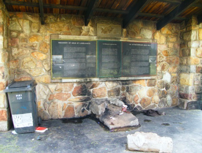
In 2002, before the World Summit on Sustainable Development took place in Johannesburg, Eric Itzkin (then responsible for “fixed heritage” at the City of Johannesburg) arranged for GHP to be “put on the map” – and to become a tourist attraction. Together with local geologists (who spent considerable effort on this) descriptive ‘black granite’ rock plaques were created, a large specimen of conglomerate ore was obtained, cut and polished, and set in place in the covered stamp mill area. At that time it looked good and we were well-pleased with the work done. It was not long before the steel fencing in front of the old working was stolen – cut off at the base. A high concrete paling fence was erected around the entire park area, and the gates were kept locked for a time. Soon the large polished specimen of pyritic conglomerate disappeared, which must have taken several people and a truck to move. In 2003 the stamp mill was partly destroyed and its shed left in ruins. Since then it’s been a slow downward drift. But even 12 months ago it looked reasonable but then the zama-zamas (illegal artisanal miners) arrived...
Descriptive rock plaques in the now ruined “crushing shed”. The situation today is more dire with garbage everywhere and greater fire damage
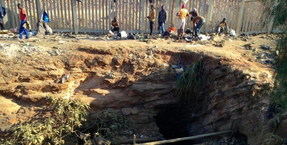
What it looked like about a year ago. All woodwork and posts have now been removed, presumably by the zama-zamas who are almost certainly working underground
I think at best we can say is that GHP is not high on City Parks list of priorties and probably never will be, and for good reason. The park itself is an anomaly, with no defined users (except the occasional visiting geologist) and is essentially defenceless as it is. Never once have I ever seen it being used as a general park; I have on several occasions seen the grass being cut, and the weeds being removed. There is no security and it would not be viable to have any. Today all the wooden and steel railings have been removed, and the old mine working and the ruins of the stamp mill site is a potentially dangerous “nest” of zama-zamas, extracting what they can in the nearby open-cast, and possibly underground.
Recent mining activity and the zama-zamas
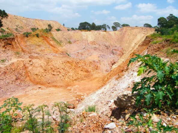
Recent opencast mining activity by Central Rand Gold has come within a few metres of the site, and it is probably only a matter of time before the old workings start to collapse into the recently created open-pit. The old workings are, in my opinion, in a structurally precarious position, with the possibility of sidewall collapse into the open-pit waiting to happen. Mining so close should never have been allowed, indeed no mining within say 100 m should have been carried out. This would probably have been the case if a proper environmental and heritage assessment had been carried out and strictly followed.
A recent view of the new CRG open-cast working taken from directly outside of the concrete security fence
The concluding reality and a solution
There are probably few people in Johannesburg, other than geoscientists and historians, who have much of an idea what the park is about. While it is arguably one of South Africa’s most important geological sites, I do not believe that there is a realistic case for preserving the site as it is. Let us not get emotional about this; progress and development happens, mistakes are made and geosites get destroyed. Nevertheless an innovative and safe solution is required to conserve this incredible geological heritage, and that does not only have to be on-site. I want to plant a seed as what may be a feasible two-fold solution:
A large size part of the rock strata (the MR, MRL and adjacent weathered quartzite beds) are cut and carefully removed, and sent to some suitable place for conservation, display and explanation. This could be the CoJ’s Geological Museum, or an open-air display in Hollard/Main Street, maybe even a special display at Gold Reef City (where the tourists really go to). A mock-up of part of the existing workings could be created. This would be a delicate job, and a professional quarry-type company should be consulted and employed. At the same time this would leave a newly exposed face and floor still within the old working. The technology and expertise no doubt exists and can be sorted later.
The old workings and the newly exposed reefs would continue to exist and be protected in a manner that the CoJ can effectively manage. Having said that I do not hold out for a long-term future for the site. The park (which is next to useless, see above) could be “de-proclaimed” and the entire site re-developed – it must be valuable land. The condition on the new lessee (or owner) would be that they conserve only the old mine working and allow controlled access to the geosite. The rest of the park is an unnecessary burden.
The stonework gateway (erected in 1947 and hardly maintained thereafter) with its engraved stone explanations, in both English and Afrikaans, could be moved or they could stay in place, for the new occupier. If the latter then at least one should be copied for the proposed new location. The choice of that “person” needs to be carefully considered and managed. If possible the engraved stone plaques now mounted in the ruins of the “crusher shed” should be removed and go with the large specimen, for display and explanation (or copies made).
Gavin Whitfield in his personal capacity -16th September 2014
Comments will load below. If for any reason none appear click here for some troubleshooting tips. If you would like to post a comment and need instructions click here.

